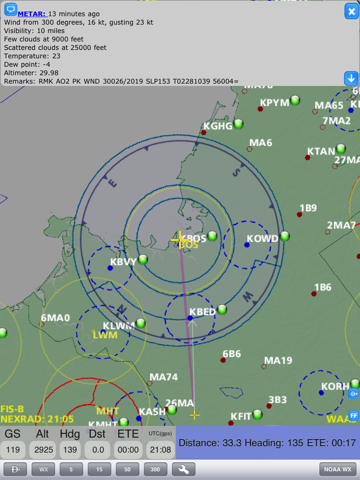
This is the application you cannot afford to fly without. SkyRadar provides you with vital flight information that enables you to fly with increased safety. The easy to use map based interface displays FAA flight database airport and airspace information along with terrain information. In addition, the application displays your GPS location, altitude and heading in real-time and allows the user to set destinations based on database lookup or map location.
When combined with the SkyRadar ADS-B Receiver, NEXRAD, TAF, METAR, NOTAM and local air traffic data will be sent via wireless connection to your iPad and overlaid on the map display. Please visit http://www.skyradar.net for more information about the SkyRadar ADS-B Receiver.
SkyRadar allows for a 1 month free evaluation period where all application features are enabled. After the evaluation period users will be prompted to activate SkyRadar with a 6 month or 1 year subscription for a low cost. The subscriptions provide access to airport and airspace information updates released every 28 days. Without a valid subscription, SkyRadar will operate as normal, but will only display airports with runways longer than 8000 feet.
Key application features:
-Easy to navigate map display with most important navigation information overlaid
-Track up vector map orientation
- 90 meter resolution lower USA terrain database
-Complete database of airports and intersections stored locally on your device
-Vector map of airspace: class B, C, D, warning/alert/restricted/military operating areas
-Display of terrain proximity map
-Airport information lookup:
Public/private, runway name, length, elevation, surface type, frequencies for tower, ground, approach, clearance, weather, runway lights
-Graphical image of the runway is shown when available
-Airport weather and NOTAM data when connected to SkyRadar ADS-B receiver
-Instantly determine information such as distance, bearing and time to reach to any object on the map by panning map to the object of interest
-When connected to our SkyRadar receiver following additional information is presented:
Overlay TIS-B and FIS-B data on the map
Depicts NEXRAD data
Presents TAF & METAR data for airports
Complete flight data with weather information can be recorded and replayed at later time
-Airspace database updated every 28 days
-Airport database updated every 56 days
-One tap "destination" setup
***
Were always interested in hearing feedback on how we can improve our application and make it more appealing to our users. Please submit any comments to [email protected]
-SkyRadar Team
***


